| |
|
|
|
|
OPENED |
|
|
COMMISSIONED |
|
|
PAID OFF |
15 May1944? to Care & Maintenance On books of H.M.S. 'Tana' |
|
CLOSED |
|
|
|
|
|
FUNCTION |
Facilitates for disembarked units.
[Emergency landing ground only while under Care &
Maintenance] |
|
ADDRESS |
R.N. Air Section.
Voi,
Kenya,
East Africa |
|
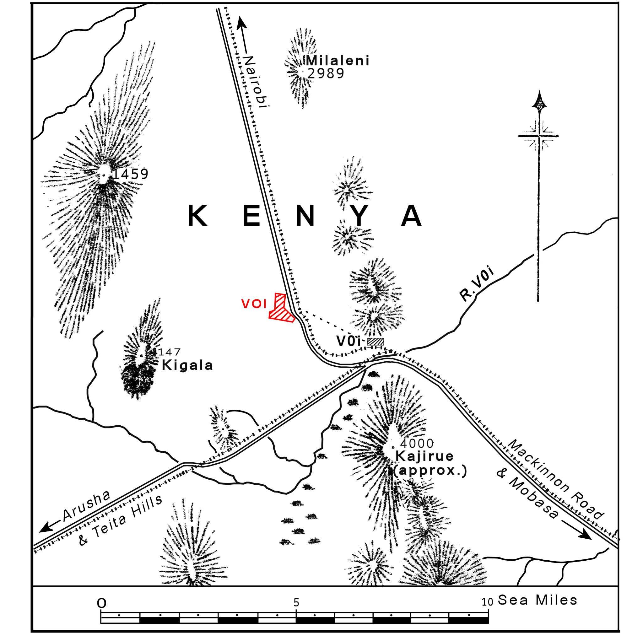
LOCALITY |
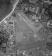
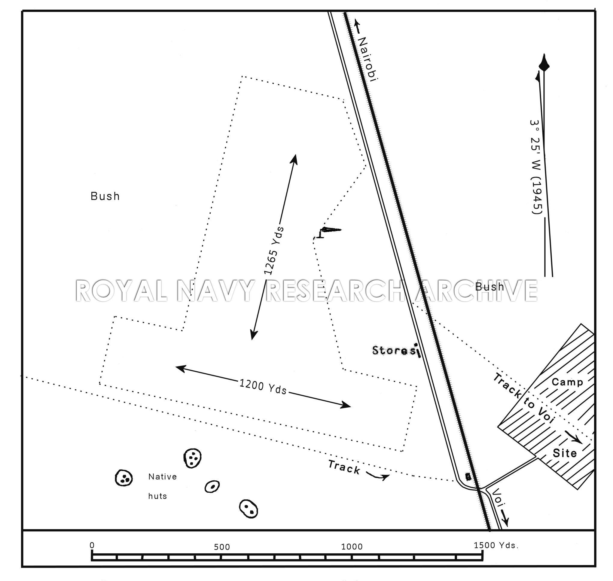
The airfield lies on a
high, bush-covered plateau 2½
miles WNW. of the small town of Voi, and on the W. side
of the Mombasa-Nairobi road and railway running NNW.
from that town. R.N.A.S. Mackinnon Road lies 39 miles
SE. buy E. Kilindini Harbour, Mombasa, lies 79 miles SE
by E.. Nairobi lies 164 miles NW. |
|
LANDMARKS |
The railway station at Voi, with three railway lines,
and adjacent roads, radiating NNW. to Nairobi SE. to
Kilindini and SW. by W. to Arusha, respectively. |
|
ROAD AND RAIL ACCESS |
Access to Kilindini by rail and road.
By rail the journey to Kilindini takes 36 to 40 hours
for goods, and is unsuited to the towing of aircraft.
The distance by road is 6o miles (R) ; the road is
not very good, and is unsuited to the towing of
aircraft.
Kilindini harbour is equipped with deep-water berths and
several 3- and 5-ton electric mobile cranes. A 10-ton
crane and a 60-ton floating crane available. |
|
| |
|
|
|
|
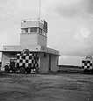
CONTROL |
No Control Building. |
|
ELEVATION |
2000' above M.S.L. |
|
RUNWAYS /LANDING AREA |
Irregular. Hard p-packed red, sandy soil, liable to
become soft after heavy rain. Maximum runs available:
NNE/SSW .... 1265 yds.
WNW/ESE ....1200 yds
|
|
TRACKS |
None |
|
OBSTRUCTIONS |
Mountains rising to 2,500' above the airfield 3 to 5
miles and about 2,000' above 41/2 miles SE. |
|
APPROACH |
None. Safest approach in low visibility, to avoid high
ground, is from the N., S. or SW., but except for narrow
gaps the ground rises to at least 1,000' above the
airfield within a 7 mile radius.
|
|
WIND INDICATOR |
One windsock, in the NE corner of landing area. |
|
|
|
|
 |
|
|
|
|
HOMING - VISUAL |
None |
|
HOMING--RADIO |
None |
|
APPROACH - VISUAL |
By day - None By night - None. |
|
APPROACH - RADIO |
None. |
|
COMMUNICATION EQUIPMENT |
W/T station complete. details mot known, but one
channel exists to R.N.A.S. Nairobi, Port Reitz and
Tanga. |
|
GROUND RADAR |
None.
|
|
| |
|
|
|
|
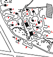
Before work on this station was stopped in 1944, the
following facilities were completed:- |
|
ACCOMMODATION |
Limited sanction and ablution facilities for 40 Officers
and 100 ratings at an adjacent camp site whish could
accommodate a tented area.
|
|
STORES |
One building for main stores and one for victualling
stores, completed. |
|
ARMOURIES |
None. |
|
COMPASS BASE |
None. |
|
DISPERSAL |
None. |
|
HANGARS |
None. |
|
MEDICAL |
There is a missionary Doctor at Teita Hills, distant
about 35 miles W. |
|
METEOROLOGICAL |
Prevalent winds : November to March are NE. April to
September are SE.
Rainy seasons : March to May and October and November.
The weather is suitable for flying all the year except
for occasional days when the strips are U/S due to rain.
No service while on Care & Maintenance.
|
|
FUEL AND OIL |
|
Aviation: |
Not known. |
|
M/T: |
Not known. |
|
Oil : |
Not known. |
|
|
TEST BASE |
None. |
|
TEST BUTT |
None. |
|
WORKSHOPS |
None. |
|
BOMBING AND FIRING RANGES |
None. |
|
|
|
|
|
|
|
Information taken from CB 4368 B. Admiralty Handbook
of Naval Air Stations Aug. 45 |
|
 |
List of first and second line squadrons, station
flight and other flying units based at this location
List of first and second line squadrons, station
flight and other flying units based at this location |
|
|
|
|
|
No squadrons are recorded as based at this station
|
 |
|
PAGE UNDER
CONSTRUCTION
Click here for a list of
Primary sources
Additional sources:
|
|
|
| |
|
|
|
© 2013 Tony Drury
www.royalnavyresearcharchive.org.uk
|


Comments (0)