| |
|
|
|
|
ACQUISITION |
Transferred on loan from R.A.F. 1.5.1943
|
|
OPENED |
|
|
COMMISSIONED |
15 May 1943 |
|
PAID OFF |
31 June 1959 to C & M. Airfield maintained but curtailed.
|
|
CLOSED |
26 April 1947 |
|
PARENT STATION TO: |
RNAS Maydown
15.5.1943 to 1.1.1944, again from 31.9.1945
|
|
|
|
|
C.O. |
|
|
|
|
|
FUNCTION |
Accommodation for disembarked Front-line squadrons.
Squadron Forming Unit.
No.2 Seafire Servicing Unit.
No. 3 Naval Fighter School.
Joint Anti-Submarine School.
Sono-bouy Training
Nucleus of Air Radar School.
All weather airfield.
|
|
ADDRESS |
R.N. Air Station Eglinton,
Londonderry,
Northern Ireland.
|
|
LOCALITY
|
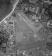
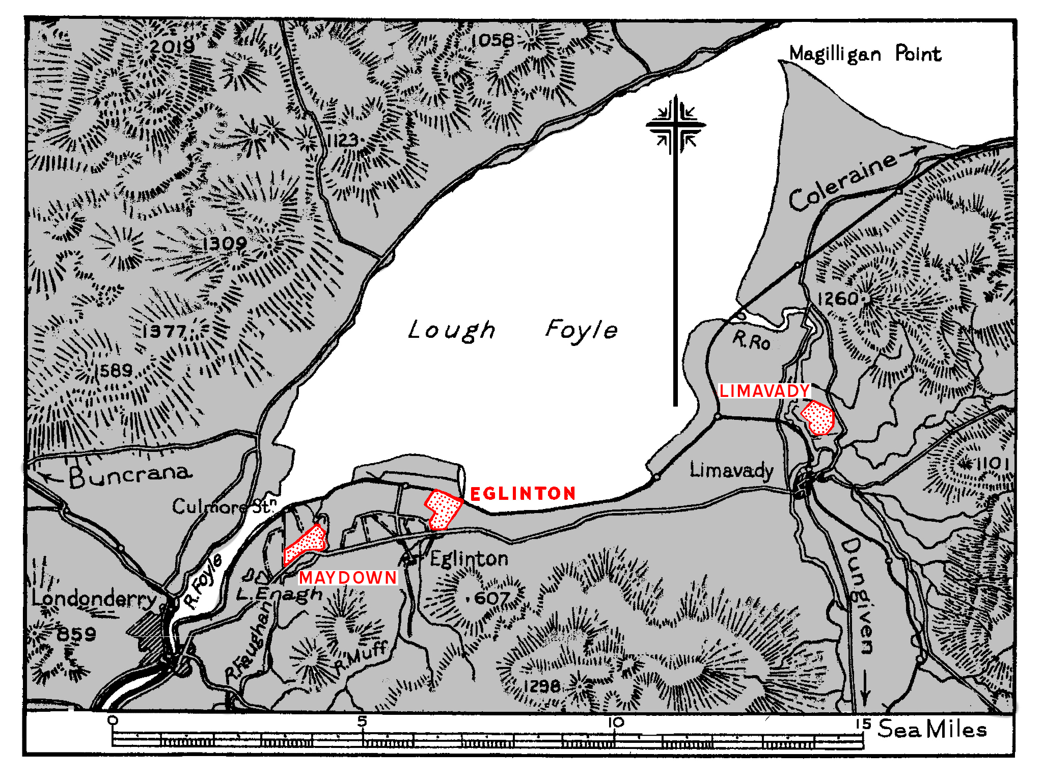
The airfield lies on the S. shore of Lough Foyle,
between the coastal railway and road, 2½
miles E. of the mouth of the River Foyle, and 1 mile NE.
of the village of Eglinton. Londonderry lies 6½
miles WSW.
|
|
LANDMARKS |
Lough Foyle and the River Foyle, with Londonderry on its W.
bank. The coastal railway and road, skirting the airfield's
N. and S. boundaries respectively.
|
|
ROAD AND RAIL ACCESS |
Main road communication with Londonderry, distant 8 miles
(R). Access. by secondary road to Eglinton station, 2 miles
(R) WNW. on the Londonderry-Belfast line.
Extensive port facilities at Londonderry with depth up to
24' alongside the quays and cranes with capacities up to 35
tons. |
|
| |
|
|
|
|
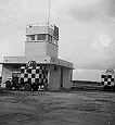
CONTROL |
Control Building on the S. side of the landing area,
inside the perimeter track.
Keeps watch o800—sunset or 1800, whichever is the
earlier, Mondays to Fridays ; o800— 200 on Saturdays ;
as required for night flying ; as ordered by Flag
Officer (Air) for essential commitments.
|
|
ELEVATION |
20' above M.S.L.
|
|
RUNWAYS /LANDING AREA |
Three, tarmac.
Extensibility
03/21 QDM. 030°/218° .... 1100 X 50 yds.
Nil
09/27 QDM. 088°/268° .... 1600 X 50 yds.
Nil
15/33 QDM. 153°/333° .... 1083 X 50 yds.
Nil
|
|
TRACKS |
50' perimeter track.
|
|
|
|
|
OBSTRUCTIONS |
Navigation |
Mountain, 1298', 4 miles SE.
Considerable mountain ranges lie to the NW., but beyond
a 5 miles radius from the airfield. |
|
Circuit |
Land rising to 600' distant noo yds. SSE. |
|
Approach |
Land rises steadily to 25o' at a distance of 170o yds.
from the 33 end of runway 15/33. |
| |
|
|
APPROACH |
Recommended sector, mean QDM. :.
|
|
WIND INDICATOR |
Windsock 15o yds. NW. of Control building. |
|
|
|
|
 |
|
|
|
|
HOMING—VISUAL |
By day - |
None |
|
By night - |
Airfield lighting, Mark II. |
|
|
|
|
HOMING--RADIO |
D/F - |
M/F, H/F and VH/F. |
|
Beacons - |
YG, AN/CPN6 and 251MS. |
|
|
|
|
APPROACH—VISUAL |
By day - |
Not known. |
|
By night - |
Not known. |
|
|
|
|
APPROACH—RADIO |
No
ne |
|
COMMUNICATION EQUIPMENT |
M/F & H/F |
17 transmitters, 7 receivers. |
|
VH/F |
9 transmitters, 1o receivers. |
|
|
|
|
CALL SIGNS |
R/T |
EGLINTON |
|
W/T |
MAQ |
|
Identity letters |
JR (later GN) |
|
|
|
|
GROUND RADAR |
Aircraft direction using low cover Radar set with
Interrogator.
|
| |
|
|
| |
|
|
|
|
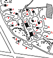
ACCOMMODATION |
In dispersed camps lying from half to z mile (R) SSW.
of the airfield.
Capacity:
|
Officers: |
212 |
|
Chiefs, P.O.s and ratings: |
1,415 |
|
W.R.N.S. Officers: |
21 |
|
W.R.N.S. Chiefs, P.O.s and ratings; |
234 |
Married accommodation at
Maydown.
|
|
ARMOURIES |
4-6 squadron scale.
|
|
COMPASS BASE |
Two. One on W. side, the other on E. side of airfield,
diameter 6o' and 7o' respectively.
|
|
DISPERSAL |
10 A/c standings and 12 pens dispersed around the
perimeter track. Two aprons, 340' x 120' and 600' x 8o',
off the perimeter track close E. and W. of the Control
building respectively.
|
|
HANGARS |
On N.E. side of the landing area.
|
Number /Type |
Size |
Door Height |
Door Width |
|
2 Type T.1 |
175' x 90' |
25' |
90' |
|
1o Fromson |
70'x 92' |
17' |
55' |
|
12 Blister |
65' x 45' |
19' 10" |
54' |
|
|
|
|
MEDICAL |
Station sick quarters situated by the cross roads at St.
Canices Church, Eglinton, distant z miles (R) SW.
|
|
METEOROLOGICAL |
Office in the Control building. Limited service by Naval
personnel.
|
|
FUEL AND OIL |
|
Aviation: |
72,00o gallons (main installation). |
|
M/T: |
5,00o gallons. |
|
Oil : |
7,00o gallons. |
|
|
|
|
|
TEST BASE |
A/C Radar base available.
|
|
TEST BUTT |
M.G. test butt available, 25 yd. range on N. side of
airfield.
|
|
WORKSHOPS |
Workshops to 4-6 squadron scale.
|
|
BOMBING AND FIRING RANGES |
Not known. |
|
|
|
|
|
|
|
|
|
|
Information taken from CB 4368 A.
Admiralty Handbook of Naval Air Stations Aug. 45 |
|
 |
List of first and second line squadrons, station
flight and other flying units based at this location |
|
|
|
|
700W
|
|
|
706
|
|
|
718
|
|
|
719
|
|
|
725
|
|
|
737
|
|
|
737X
|
|
|
744
|
|
|
745
|
|
|
758
|
|
|
768 |
|
|
782
|
|
|
794
|
|
|
795
|
|
|
800 |
|
|
802 |
|
|
803 |
|
|
804 |
|
|
805 |
|
|
806 |
|
|
807 |
|
|
808 |
|
|
810 |
|
|
811 |
|
|
812 |
|
|
813 |
|
|
814 |
|
|
815 |
|
|
816 |
|
|
817 |
|
|
819 |
|
|
820 |
|
|
821 |
|
|
824 |
|
|
825 |
|
|
827 |
|
|
833 |
|
|
834 |
|
|
835 |
|
|
837 |
|
|
838 |
|
|
845 |
|
|
847 |
|
|
848 |
|
|
849 |
|
|
849D |
|
|
849D |
|
|
850 |
|
|
852 |
|
|
853 |
|
|
856 |
|
|
878 |
|
|
881 |
|
|
882 |
|
|
883 |
|
|
886 |
|
|
887 |
|
|
890 |
|
|
891 |
|
|
892 |
|
|
894 |
|
|
896 |
|
|
898 |
|
|
1830 |
|
|
1831 |
|
|
1833 |
|
|
1835 |
|
|
1837 |
|
|
1840 |
|
|
1841 |
|
|
1842 |
|
|
1843 |
|
|
1844 |
|
|
1845 |
|
|
1846 |
|
|
1847 |
|
|
1850 |
|
|
1851 |
|
|
1852 |
|
 |
|
PAGE UNDER CONSTRUCTION
Click here for a list of
Primary sources
Additional sources:
Admiralty Fleet Orders:
Confidential Admiralty Fleet Orders:
|
|
|
| |
|
|
|
|


.jpg)
Comments (1)
Hi I am trying to find information on Mary A C Grey who was a WRNS in July 1954. The MOD are not releasing records at the moment. Is there a history society for this regiment please? Thank you, Rachel Cass Rachel.cass@hotmail.com