| |
|
|
|
|
ACQUISITION |
Transferred from RAF 15.07.1942 |
|
COMMISSIONED |
01.08.1942 on 'Books of 'Merlin'
11.10.1942 as 'OWL'
|
|
CLOSED |
|
|
PAID OFF |
02.07.1946 to C & M status On books of 'Fulmar' at 6
months notice to reopen.
|
|
C.O./O.I.C. |
|
|
|
|
|
FUNCTION |
Barracuda Operational Training UnitNo. 2 Torpedo School
No. 1 Avenger Servicing Unit,
No. 1 Barracuda Servicing Unit.
No. 3 Barracuda Servicing Unit.
Accommodation for disembarked squadrons.
|
|
ADDRESS |
R.N. Air Station
Fearn,
Ross-Shire,
Scotland.
|
|
LOCALITY
|
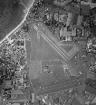
The airfield, situated 1 mile SSE. of the village of
Fearn, lies 1 mile from the NW. shore of the Moray Firth
and 4 miles NNE. of North Sutor, the N. entrance point
to Cromarty Firth.
Invergordon lies 8½ miles SW. Inverness lies 19 miles
SSW.
|
|
LANDMARKS |
Tarbat Ness, 8 miles NE., dividing Dornoch Firth to the NW.
from Moray Firth to the SE.
Cromarty Firth stretches W. and then. SW. from North Sutor.
|
|
ROAD AND RAIL ACCESS |
A main road, skirting the NE. boundary of the airfield runs
SW. to Invergordon 14 miles (R), and Dingwall, 27 miles (R),
and SE. to Balintore, on the coast, 1 mile (R).
Fearn railway station, on the Invergordon lines, lies 3
miles (R) WNW. of the airfield. |
|
|
|
|
| |
|
|
|
|
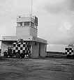
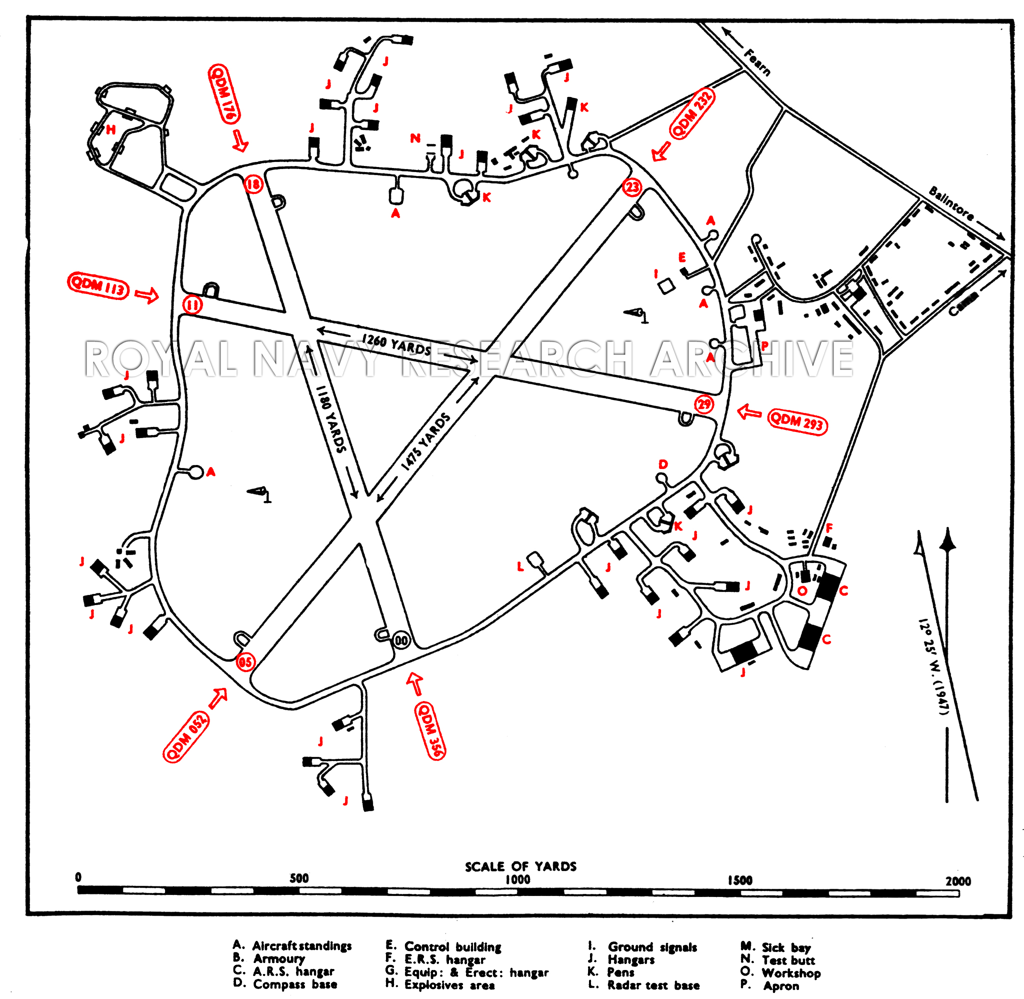
CONTROL |
Control Building inside the perimeter track on the NE.
side of the landing area
|
|
ELEVATION |
25' above M.S.L.
|
|
RUNWAYS |
Three, tarmac.
Extensibility
00/18 QDM. 356°/176° .... 1,180 X 50 yds.
1400
05/23 QDM. 052°/232° .... 1,475 X 50 yds.
3000
11/39 QDM. 115°/295° .... 1,260 X 50 yds.
3000
|
|
TRACKS |
40' perimeter track.
|
|
OBSTRUCTIONS |
Navigation |
Hill of Nigg, summit 666', distant 2¼miles SSW. |
|
Circuit |
Northern slopes of Hill of Nigg, about x mile S. |
|
Approach |
None.
|
|
APPROACH |
Use of Runway 00/18 is subject to the following
limitations :-
(a) Approach on circuit over I Iill of Nigg to be made
at not less than 1000'.
(b) Height should only be lost when in direct line of
runway extended.
(c) Height over funnel should be not less than 500'.
|
|
WIND INDICATOR |
|
|
|
|
|
 |
|
|
|
|
HOMING - VISUAL |
By day |
None. |
|
By night |
None.
|
|
HOMING--RADIO |
D/F |
|
|
Beacons |
|
|
APPROACH - VISUAL |
By day |
None. |
|
By night |
|
|
APPROACH - RADIO |
|
|
COMMUNICATION EQUIPMENT |
M/F & H/F |
transmitters, receivers. |
|
VH/F |
transmitters, receivers. |
|
CALL SIGNS |
R/T |
|
|
W/T |
|
|
Identity letters |
|
|
|
|
|
GROUND RADAR |
|
|
|
|
|
| |
|
|
|
|
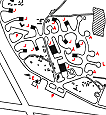
ACCOMMODATION |
Officers and ratings, living quarters in dispersed sites
beyond the NE. boundary.
Capacity:
|
Officers: |
147 |
|
Chiefs, P.O.s and ratings: |
1.708 |
|
W.R.N.S. Officers: |
18 |
|
W.R.N.S. Chiefs, P.O.s and ratings; |
529 |
Note: Accommodation figures
are those at time of reduction to C. & M. and are on
war-time austerity scales.
|
|
ARMOURIES |
|
|
COMPASS BASE |
One, tarmac diameter 70'.
|
|
DISPERSAL |
6 small and 2 large A/c standings and 6 double pens.
|
|
HANGARS |
Dispersed round the perimeter track
|
Number /Type |
Size |
Door Height |
Door Width |
|
2 Type T.3 .. |
66' x 75' |
19' |
66' |
|
30 Mains.. |
60' x 70' |
17' |
55' |
|
3 Callender-Hamilton.. |
110' x 185' |
25' |
100' |
|
|
|
|
MEDICAL |
|
|
METEOROLOGICAL |
|
|
FUEL AND OIL |
|
Aviation: |
Not known. |
|
M/T: |
Not known. |
|
Oil : |
Not known. |
|
|
|
|
|
TEST BASE |
A/C radar base on SE. of landing area.
|
|
TEST BUTT |
Test butt and 25 yd. range available.
|
|
WORKSHOPS |
Workshops 4-6 squadron scale.
|
|
VISITORS |
|
|
EXPLOSIVES |
|
|
BOMBING AND FIRING RANGES |
|
|
Air to air |
|
|
Air to ground and R. p. Firing |
|
|
Live and practice bombing |
|
|
Practice bombing |
|
|
Assault training |
|
|
|
|
|
|
|
|
Information taken from CB 4368 B. Admiralty Handbook
of Naval Air Stations Aug. 45
|
|
 |
List of first and second line squadrons, station
flight and other flying units based at this location |
|
|
|
|
708
|
|
|
714
|
|
|
717
|
|
|
719
|
|
|
736B |
|
|
7
47 |
|
|
812 |
|
|
814 |
|
|
815 |
|
|
816 |
|
|
817 |
|
|
818 |
|
|
819 |
|
|
821 |
|
|
822 |
|
|
823 |
|
|
824 |
|
|
825 |
|
|
826 |
|
|
828 |
|
|
837 |
|
|
841 |
|
|
847 |
|
|
860 |
|
 |
|
PAGE UNDER
CONSTRUCTION
Click here for a list of
Primary sources
Additional sources:
Admiralty Fleet Orders:
Confidential Admiralty Fleet Orders:
|
|
|
| |
|
|
|
|


Comments (1)
Dear Sirs, I am a researcher of the history of ALL Army in the Netherlands-Indisch at the period of 1945-1950.
At the time 1946 the 860 Squadron (Dutch) was stationed at RNAS FEARN and exercised the ADDL's.
Can you please help me with the drawings and instructions for this ADDL's??
Many thanks in advance,