| |
|
|
|
|
ACQUISITION |
Lodger facility for an RN Air Section on RAF station
from 01 April 1940.
Transferred from RAF
to Admiralty 16 March 1943 |
|
COMMISSIONED |
22 March 1943
|
|
PAID OFF |
31 December 1944 to Care & Maintenance on books of
'ELAND'
AFO 2541/44 & 7504.45 |
|
CLOSED |
|
|
|
|
|
FUNCTION |
Reserve aircraft storage.
Facilities for disembarked
squadrons.
Torpedo facilities.
Fleet Requirements unit (777 NAS)
|
|
ADDRESS |
R.N. Air Station,
Hastings,
Freetown,
Sierra Leone |
|
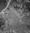
LOCALITY |
The airfield is situated on the Sierra Leone peninsula,
8 miles SE. of Freetown, and ½ mile NE. of the village
of Hastings. It lies between Hastings creek and
"Kingfishers' creek", tributaries of the Bunce River,
and immediately N. of of the Sierra Leone Government
railway line form Freetown.
R.A.F. seaplane base at
Jui lies one mile N. on Hastings creek. |
|
LANDMARKS |
.The Sierra Leone peninsula and the mouth of the
Sierra Leone river, with Freetown on its S. shore.
The
Bunce river flowing NW. into the Sierra Leone river.
The Sierra Leone Government railway line, forming the
airfield's S. boundary.
Creeks flowing into the Bunce river form W. and SE.
boundaries off the airfield, Mangrove swamps extend from
its N. side to the river.
|
|
ROAD AND RAIL ACCESS |
Access by road to Hastings and to the main road to
Freetown, distant11½ miles (R).
The airfield has its
own railway siding; railway station at Hastings,
adjacent S. of airfield, is on the direct line to
Freetown.
A small wharf in Hastings creek, W. of the airfield,
gives access by water to Jui and, via Bunce river, to
Freetown.
Jetties connected to the railway system at Freetown,
where unloading is carried out by lighters; cranes at
the jetties with a lifting capacity of 10 tons. |
|
| |
|
|
|
|
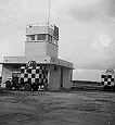
CONTROL |
Control building at S. end of airfield in front of
the hangers.
Caution:
Bumpy conditions may be experienced in the vicinity
of the adjacent mountains. For night flying when winds
are usually light and variable, approach should be made
with care and preferably on QDM.267°, touching down at
the "27" end of the runway, but not E. of the white line
which marks the beginning of a steep down slope towards
the end of the runway.
It is dangerous to overshoot owing to difficulty in
taking off again over the mountains.
|
|
ELEVATION |
95' above M.S.L.
|
|
RUNWAYS /LANDING AREA |
One, Laterite, tar sprayed and sanded:
09/27 QDM. 087°/267° .... 1400 X 50 yds.
There are in addition three cleared strips, not suitable
for landing or take-off. These lie NW/SE., NNW/SSE
and NE/SW (partly concreted), across the runway ; the
NNW/SSE strip is used as a dispersal area in its
southern portion, the other two are as taxi strips.
|
|
TRACKS |
40' taxi strip leading from the S. hangar area to the
runway in the vicinity of the E. hangar area.
|
|
OBSTRUCTIONS |
Navigation:
|
Mountains from SE,., through S., to NW., rising to 2419'
and 2418' at 31/2 mile4s W. and 3 miles S.,
respectively. |
|
Circuit: |
Foothills of a spur of these mountains begin to rise
close to the landing area (796' at 11.2miles SE.).
Hill, 293' distant 20000 yds S. by W.
Hill, 1896' distant 2600 yds NW.
|
|
Approach: |
None, but see "caution" under 'control'.
|
|
APPROACH |
No safe approach sector designated.
|
|
WIND INDICATOR |
Windsock mast S. of the runway ,near its centre. |
|
|
|
|
 |
|
|
|
|
HOMING - VISUAL |
By day:
By night:
|
Not known
Not known
Equipment removed when station reduced to
care & maintenance
|
|
HOMING - -RADIO |
D/F: Beacon:
|
Not known
Not known
Equipment removed when station reduced to
care & maintenance
|
|
APPROACH - ÂVISUAL |
By day:
By night: |
Not known
Not known
|
|
APPROACH - RADIO |
Not known
Equipment removed when station reduced to
care & maintenance
|
|
COMMUNICATION EQUIPMENT |
W/T and R/T:
VH/F:
|
Not known
Not known
Equipment removed when station reduced to
care & maintenance
|
|
GROUND RADAR |
None. |
|
| |
|
|
|
|
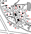
ACCOMMODATION |
Living quarters at two camps on S. & NE. of the
airfield:-
Capacity:
|
Officers: |
`04 |
|
Chiefs, P.O.s and ratings: |
1015 |
|
W.R.N.S: |
None. |
|
Natives: |
300 |
|
|
ARMOURIES |
To accommodate 2 - 3 squadrons.
|
|
COMPASS BASE |
One; diameter 60'
|
|
DISPERSAL |
Two, Laterite, tar sprayed, approx 450 x 50 yds., and 70
x 50 yds., forming the southern part of the NNW/SSE
cleared strip, can be used for dispersal.
|
|
HANGARS |
At the S. and E. ends of the landing area. All
hangars fronted by cement or tarmac aprons.
|
Number /Type |
Size |
Door Height |
Door Width |
|
4 Bellman |
.175' x 95' |
25' |
87' 9"' |
|
|
|
|
MEDICAL |
Sick quarters on S. side of airfield. Two sick Bays, one
in each camp.
|
|
METEOROLOGICAL |
Air Ministry provide facilities.
Tornadoes, liable at
the beginning and end of the SW. monsoon period (May -
October), usually blow from the E., enduring for about
40 minutes at force 6, but may attain gusts up to 60
knots.
Visibility, usually good,
may fall to 500 yds. in dust haze during Harmattan
(easterly) season (December - February). Morning
mist, sometimes dense, is prevalent throughout thee
year, nut rarely persists after 0900 hours. Cloud base
is frequently well below he tops of the mountains. |
|
FUEL AND OIL |
Aviation .............. Two tanks of 37000 gallons
capacity each. |
|
M/T......................Storage capacity of 3000
gallons. |
|
Oil ....................... No tank storage |
|
|
|
SLIPWAY |
Slipway and small concrete apron on the bank of a creek
at the extreme NE. of the airfield. 2 -ton and 5-ton
Coles cranes, for use at the slipway
Three A/C
moorings rte situated off the slipway..
The creek is known locally as "Kingfisher Creek" and
gives access to the Bunce river, distant about 1500 yds.
Three additional moorings are available off the
wharf ob Hastings creek on the W. side of the airfield;
this creek gives access to the R.A.F. Seaplane Base at
Jui, distant abut 2¼ miles by water, and thence to Bunce river, a further
¾ mile.
Aircraft alight in the river and taxi up the creek;
facilities arte suitable only for small type seaplanes.
|
|
TEST BASE |
Not A/C radar base.
|
|
TEST BUTT |
Not known
|
|
WORKSHOPS |
To 2 -3 squadron scale.
A site has been reserved
for the possible post-war development of the station as
an R.N. Aircraft Maintenance Y Yard.
|
|
BOMBING AND FIRING RANGES |
|
|
R. P. Firing: |
One |
|
|
|
|
|
|
|
Information taken from CB 4368 B. Admiralty Handbook
of Naval Air Stations Aug. 45
|
|
 |
List of first and second line squadrons, station
flight and other flying units based at this location |
|
|
|
|
710 |
Catapult
Squadron
Operated ashore from the parent ship HMS ALBATROSS
between 12 - 26.01.40.
Detachments operated ashore between 31.07.40 and
14.05.41 when entire squadron again
disembarked. Re-embarked in ALBATROSS 23.09.41
Disembarked from ALBATROSS 17-27.11.41
Detachment of 2 a/c 22.12.42 to 23.02.43
Equipped
with 9 Supermarine Walrus
|
|
777 |
Fleet Requirements Unit
Formed here 01.08.41.
Disbanded 25.12.44.
Equipped with Fairey Swordfish, Blackburn Roc,
Bolton-Paul Defiant, Supermarine Walrus.
|
|
814 |
Torpedo,
Spotter, Reconnaissance squadron
Disembarked from HMS HERMES
29.10.39. Re-embarked HERMES 07.11.39.
Equipped
with 9 Swordfish
|
 |
|
PAGE UNDER
CONSTRUCTION
Click here for a list of
Primary sources
Additional sources:
Admiralty Fleet Orders:
7504/45.—West Africa Sub
Command—Closing Down of Various Bases
Confidential Admiralty Fleet Orders:
195/45 Reduction to Care and
Maintenance & Paying off
|
|
|
| |
|
|
|
|


Comments (0)