| |
|
|
|
|
OPENED |
01 Aug 1940 as part of HMS MALABAR II
|
|
COMMISSIONED |
06 Nov 1940 as HMS GOSHAWK
|
|
PAID OFF |
28 February 1946
|
|
CLOSED |
28 February 1946 |
|
|
|
|
FUNCTION |
No. 1 Observer Training School; Link Trainer (2) Free
Gun Trainier (1)
Reserve aircraft storage.
The airfield was also used by Pan Am, British West
Indies Airlines., and K.L.M. civil airlines.
|
|
ADDRESS |
R.N. Air Station.
Piarco,
Trinidad
British West Indies |
|
LOCALITY |
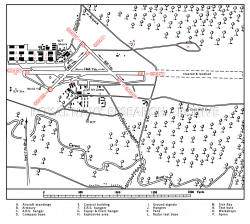
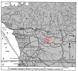
The airfield is situated on a low-lying plain 10½ miles
ESE. of Port of Spain, 400 yards from the N. bank of the
Caroni River and adjacent N. of the village of Piarco.
The village of Arouca lies 2 miles W. and St. Joseph4¾
miles NW.
|
|
LANDMARKS |
The Caroni River, flowing in a westerly direction and
entering the sea, through the Caroni swamp, 1½ miles
SSE. of Port of Spain.
The railway junction at Curepe, ½ mile SE. of St.
Joseph, where the railway from Port of Spain forks, one
branch running E. to pass within 2 miles of the
airfield's N. boundary, the other curving southwards,
and passing 2 miles W.
The airfield is marked by a circle and the name
"PIARCO" south of the "10" end of runway 10/28. |
|
ROAD AND RAIL ACCESS |
Access by road to the Churchill-Roosevelt highway, 1½
miles (R) N., and thence to Port of Spain, about 15
miles (R) WNW. Taxis and omnibuses available; good roads
to all parts of the island.
Access to the railway station at Arouca, distant 3 miles
(R) on the Trinidad Government Railway, Guanapo -
Arim - St. Joseph - Pot of Spain line. Both passengers
and freight are conveyed by this railway, although the
later is normally handled direct by road from Port of
Spain. |
|
| |
|
|
|
|
CONTROL |
Control office in Administration building, S. of runway
10.28.
|
|
ELEVATION |
37' above M.S.L.
|
|
RUNWAYS /LANDING AREA |
Three, asphalt, all-weather:
05/23 QDM.053°233° ....800X 30 yds.
1028 QDM. 097°/277° .... 1665 X 50 yds.
14/32 QDM. 142°/322° .... 800 X 30 yds.
Note: In order to facilitate a forced landing in the
event of engine failure soon after take-off, an
extension of 1335 x 50 yds. has been cleared and
levelled E. of the "29" end of runway 10.28.
|
|
TRACKS |
40' taxi-tracks connect the ends of runways and give
access to the hangar and workshop area.
|
|
OBSTRUCTIONS |
Navigation |
Mountain range rising sharply from the plain 4
miles N. and attaining elevations of 2197' 6 miles NNW.
and 2325' 5½ miles NNE. The greatest elevation of this
range is 3085', distant 9 miles NE. |
|
Circuit |
None. |
|
Approach |
None in fan. Three W/T masts, 60', on the N. side of the
airfield, 200 yds. NW. of runway 05/23.
|
|
APPROACH |
Owing to the prevailing easterly wind, the best approach
us on QDM. 110°.
|
|
WIND INDICATOR |
Two windsocks, N. and S. of runway 10/28, E. of Admin.
and R,N, buildings. An illuminated (green) "T" is
mounted S. of the "10" end of runway 10/28. |
|
|
|
|
 |
|
|
|
|
HOMING - VISUAL |
By day - |
Beacon on control tower, (revolving, white, 6 R.P.M.)
operated during QHI. |
|
By night - |
Beacon on control tower, (revolving, white, 6 R.P.M.)
|
|
HOMING--RADIO |
D/F - |
M/F manned on request |
|
Beacons - |
Carlsen Field Radio Range (DO. 382 kcs) lies 9 miles
S.W.
|
|
APPROACH - VISUAL |
By day - |
Steady white light from Control Tower is affirmative to
land. |
|
By night - |
Illuminated "T"; obstruction lights; contact lights
(runway 10/28) Flood-lights at "10" end of runway 10/28.
|
|
APPROACH - RADIO |
None.
|
|
COMMUNICATION EQUIPMENT |
M/F & H/F |
14 transmitters, 16 receivers. |
|
VH/F |
None.
|
|
GROUND RADAR |
None.
|
|
| |
|
|
|
|
ACCOMMODATION |
Living quarters at Golden Grove, close S. of Arouca and
1¾ miles (R)
N. of airfield.
Capacity:
|
Officers: |
150 |
|
Chiefs, P.O.s and ratings: |
1477 |
|
W.R.N.S. Officers: |
None. |
|
W.R.N.S. Chiefs, P.O.s and ratings; |
None. |
|
|
ARMOURIES |
To accommodate 4 squadrons.
|
|
COMPASS BASE |
Two. one fixed , one rotatable, diameter 70'.
|
|
DISPERSAL |
Apron 660 yds. fronts the hangar area N. of the "10" end
of runway 10/27.
|
|
HANGARS |
F.A.A. hangars on NW. side of airfield:
|
Number /Type |
Size |
Door Height |
Door Width |
|
3 Bellman |
87' x 105' |
25' |
105' |
|
10 Callender |
185' x 110' |
25' |
110' |
|
1 Special type |
150' x 100' |
17' |
55' |
|
Note; Four of the above hangars are utilised as
A.R.S. |
|
|
|
Civil Hangars on S. side of airfield: |
|
1 Nose Hangar
(P.A.A.)
|
68' x 48' |
25' |
- |
|
1 Nose Hangar (B.W.I.A.) |
28' x 1104' |
15' |
- |
|
1 Nose Hangar |
50' x 77' |
11' |
54' |
|
|
|
|
MEDICAL |
First Aid on airfield. Hospital (50 beds) at Golden
Grove camp.
|
|
METEOROLOGICAL |
Full service by Naval personnel. Prevailing wind,
easterly, varying ENE. and ESE. in middle and later part
of year. |
|
FUEL AND OIL |
Aviation - |
100, 87 and 73 octane. Storage capacity:
100 octane -,
20,000 gallons; 87 octane, 20,000 gallons.
Other grades supplied by Shell Co. from S. side of
airfield.
Note: Fuel supplied by Shell by pipeline or Bowser. |
|
M/T - |
2.000 gallons |
|
Oil - |
All grades available. No storage tanks. Stowed in drums. |
|
TEST BASE |
None.
|
|
TEST BUTT |
M.G. and cannon test butt and 25 yd. range.
|
|
WORKSHOPS |
.Four A.R.S. hangars, an en engine repair shop, an
electrical workshop and a radio repair shop. General
engineering shop and Radar workshop.
|
|
BOMBING AND FIRING RANGES |
|
|
Air firing and bombing range: |
One. Waterloo Range, situated in the Gulf of Paria, off
the W. coast of Trinidad. The range is an area bounded
by lines drawn between the following coordinates: |
| |
Latitude:
10° 32' 05" N.
10° 32' 05" N.
10° 17' 05" N.
10° 17' 05" N. |
Longitude:
61° 34' W.
61° 43' W.
61° 43' W.
61° 34' W. |
|
|
|
Information taken from CB 4368 B. Admiralty Handbook
of Naval Air Stations Aug. 45
|
|
 |
List of first and second line squadrons, station
flight and other flying units based at this location |
|
|
|
|
749 |
Observer Training Squadron, part of No.1 Observer
School
Formed here on 01.01.41. Disbanded 01.10.45
Equipped with Supermarine Walrus, Grumman Goose,
and Avro Anson.
|
|
750 |
Observer Training Squadron, part of No.1 Observer
School
Arrived on station 05.11.40 after being relocated
from the UK.. Disbanded 10.10.45
Equipped with Blackburn Shark, Fairey Albacore,
and Fairey Barracuda.
|
|
752 |
Observer Training Squadron, part of No.1 Observer
School
Arrived on station 05.11.40 after being relocated
from the UK.. Disbanded 09.10.45
Equipped with Percival Proctor, De Havilland
Tiger Moth, and Fairey Albacore,
|
|
793 |
Air Towed Target Unit, part of No.1 Observer School
Arrived on station 18.11.40 after being relocated
from the UK.. Disbanded 10.10.45
Equipped with Blackburn Roc, Miles Martinet
T.T.1, Fairey Fulmar, and Fairey Albacore.
|
|
817 |
Torpedo, Spotter, Reconnaissance squadron
'Z'
flight (3?) Albacore arrived here from USNAS
Norfolk. Virginia 21-09.43. Aircraft withdrawn and
re-issued to 750 squadron. Personnel departed for
USNAS Norfolk 27.09.43.
|
|
|
|
|
 |
|
PAGE UNDER
CONSTRUCTION
Click here for a list of
Primary sources
Additional sources:
Admiralty Fleet Orders:
Confidential Admiralty Fleet Orders:
|
|
|
| |
|
| |
|

|
| |
|


View Larger Map

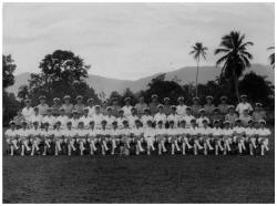
Officers and senior ratings of HMS Goshawk 1945 George
Martin, the future Beatles producer, is in this shot as n RN
navigator.
Photo: Lt.Cdr John Vallely
|
| |
|
|
Comments (1)
My uncle Sub/Lt Gervase Stewart was killed at this location when his Walrus blew up in mid-air. Do you have any information on this incident?